
Application of low-altitude unmanned aerial vehicle remote sensing technology in refined identification of dangerous rock masses on high and steep slopes in karst mountain areas
-
摘要:
为实现精细化识别岩溶山区高陡边坡危岩体,以广西罗城典型岩溶地貌区为例,综合运用机载激光雷达(light detection and ranging, LiDAR)、倾斜摄影测量、贴近摄影测量3种低空无人机遥感技术手段开展危岩体精细化调查工作。总结了基于点云数据的林下孤石和裂隙信息提取的方法,系统归纳了运用三维实景模型开展结构面产状信息提取、结构面特征参数信息提取的手段,探讨了岩溶地区高陡边坡危岩体识别和精细化调查方法,开展了研究区危岩体的精细化识别,共识别出34处危岩体。研究成果可为其他类似地区的危岩体识别工作提供技术参考。
Abstract:In order to accurately identify high and steep slope dangerous rock masses in karst mountainous areas, the authors took the typical karst landform area of Luocheng in Guangxi as an example, through three low-altitude unmanned aerial vehicle remote sensing techniques, that is airborne LiDAR, oblique photogrammetry, and close-range photogrammetry, to conduct detailed investigation of dangerous rock masses. The extracting information methods for isolated rocks and cracks under forests were summarized based on point cloud data, and the 3D real scene models were systematically summarized for extracting structural plane attitude information and structural plane characteristic parameter information. The identification and refined investigation methods of dangerous rock masses on high and steep slopes were discussed, and the refinement identification of dangerous rock masses was carried out, with a total of 34 dangerous rock bodies being identified. The research results could provide technical guidance for identifying hazardous rock masses in similar regions.
-
0 引言
我国岩溶地貌具有面积广、类型多的特点,广泛分布于广西、云南、贵州等地。岩溶山区危岩体大多发育在岩溶石山的山顶或半山腰,受地形条件影响,具有失稳时突发、破坏历时短、致灾范围广、监测预警难和危害性大等特点,严重威胁着居民的生命财产安全[1]。面对山高坡陡的岩溶山区,调查人员无法近距离开展灾害体详细勘察工作。早期众多学者将三维激光扫描仪应用到高边坡地质调查中,通过密集点云数据构建岩体高精度模型,实现了边坡快速编录和岩体结构面参数测量,开展边坡形变监测[2-4]。在此基础上,融合无人机载激光雷达(light detection and ranging, LiDAR)与地面三维激光扫描点云数据,实现了对岩体结构和裂隙信息提取[5-6]。随着无人机遥感技术的快速发展,无人机航空摄影测量技术在铁路选线设计[7]、地质灾害调查[8]、地形测绘[9]等领域得到了广泛应用。采用无人机低空摄影技术,可以快速提取危岩体空间位置[10]、裂隙宽度[11]、断裂岩层产状[12]等信息。针对高陡边坡危岩体,采用无人机贴近摄影测量技术,可以实现对危岩体的快速识别[13],提取结构面参数[14]并进一步开展稳定性分析[15]。
机载LiDAR技术能获取高精度的激光点云数据,以其雷达波的多次回波特性,可“穿透”植被覆盖直达地表,获取真地面高程数据信息[16]。无人机倾斜摄影测量及贴近摄影测量技术可获取丰富的光学影像信息。岩溶山区地形条件复杂、有植被覆盖,综合运用多源遥感技术能有效避免单一技术的局限,提高调查精度和效率。本文致力于研究如何综合应用机载LiDAR技术、无人机倾斜摄影测量技术以及贴近摄影测量技术对高陡边坡危岩体进行精细化调查,旨在为类似边坡危岩体的识别提供一种准确、快速且有效的方法。
1 研究区概况
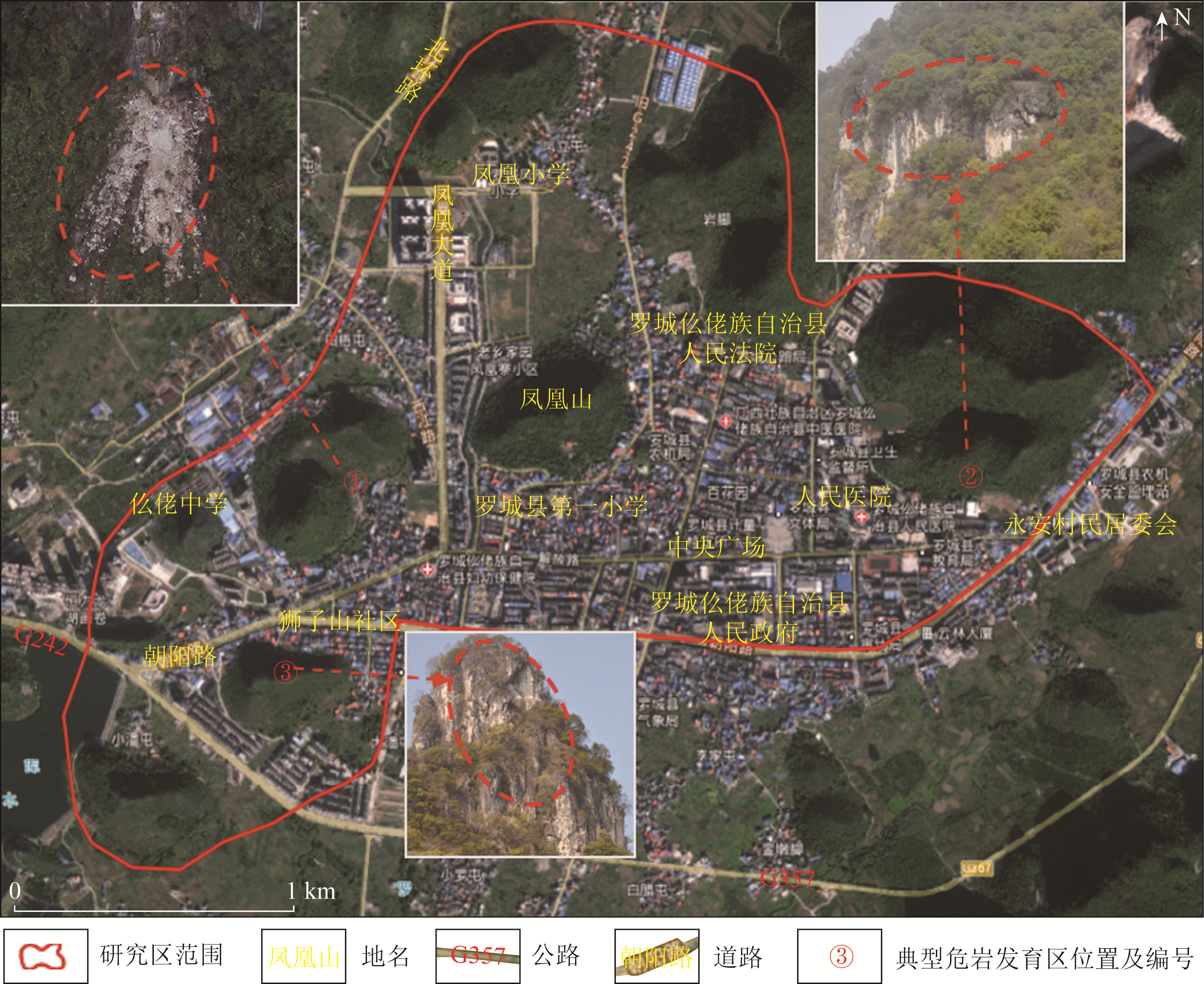
研究区位于广西罗城县城,周边地区地貌类型为峰林谷地地貌,出露地层为石炭系纯碳酸盐岩,并处在两组以上断裂交汇部位,断裂密集。谷底平坦,高程一般为300~320 m,局部发育稀疏的小型石林。谷地内及四周峰林成片、成带分布,孤峰及岩溶残山发育。峰高200~300 m,以圆锥状多见,石峰上下成层分布。由于构造节理、风化裂隙、溶洞、地下河的发育,在斜坡易产生岩质崩塌等地质灾害,在岩溶洼地、谷地中易产生岩溶塌陷等地质灾害[17-18]。本次选取罗城县城区域作为危岩遥感调查研究区,开展机载LiDAR扫描和倾斜摄影测量工作,另在区内选取3处典型危岩发育区进行无人机贴近摄影测量数据获取,研究区位置如图 1所示。
![]() 图 1 研究区和典型危岩体发育区位置Fig. 1 Location of the study area and typical development areas of dangerous rock masses
图 1 研究区和典型危岩体发育区位置Fig. 1 Location of the study area and typical development areas of dangerous rock masses2 方法及数据
2.1 技术路线
本文采用机载LiDAR、倾斜摄影测量及贴近摄影测量3种低空无人机遥感技术手段,获取研究区光学影像及激光点云数据。利用基于运动恢复重建(Structure from motion,SFM)算法的ContextCapture软件对采集的光学影像进行三维重建,生成测区的精细化三维实景模型,采用基于不规则三角网逐渐加密的算法对点云数据进行滤波、去噪和人机交互分类,生成测区数字高程模型(digital elevation model, DEM)。结合收集的地质环境数据,搭建三维解译环境,开展岩溶地区结构面特征信息提取和危岩体识别,并结合室内遥感解译及野外复核验证,对高陡边坡危岩体开展精细化调查。
2.2 数据获取
研究区内存在大量高陡边坡危岩体,研究人员难以抵达展开调查工作,本次结合机载LiDAR、倾斜摄影测量和贴近摄影测量3种技术手段展开研究,获取研究区危岩体灾害信息,各遥感数据获取情况如表 1所示。其中,机载LiDAR数据获取采用飞马D20无人机搭载DV-LiDAR20传感器,飞行采用平行航线,航线重叠度为75%,激光采集频率为200 KHz,航测高度为200 m,飞行速度为8 m/s,获取的激光点云密度为60 pt/m2。采用飞马D200搭载OP310倾斜模块完成倾斜数据采集,航测分辨率为5 cm,设计航向重叠度为80%,旁向重叠度为75%,飞行高度为319 m,飞行速度为10 m/s。针对重点危岩体区域,通过机载LiDAR采集的点云,快速生成DEM,为贴近摄影测量提供基础地形,采用DJI Phantom4RTK开展贴近数据采集,航测分辨率为5 mm,航测航向和旁向重叠率皆为80%,仿地高度为30 m,飞行速度为3 m/s。
表 1 低空遥感数据获取情况Tab. 1 Data acquisition situation of low-altitude remote sensing数据类型 工作设备 数据采集主要参数 成果类型 机载LiDAR D20+DVLiDAR20 点云密度60 pt/m2 DEM、数字表面模型(digital surface model, DSM) 倾斜摄影测量 D200+ OP310 分辨率5 cm 倾斜三维实景模型、数字正射影像(digital orthophoto map, DOM) 贴近摄影测量 DJI Phantom4RTK 分辨率5 mm 贴近三维实景模型 3 基于多源数据的危岩体信息提取
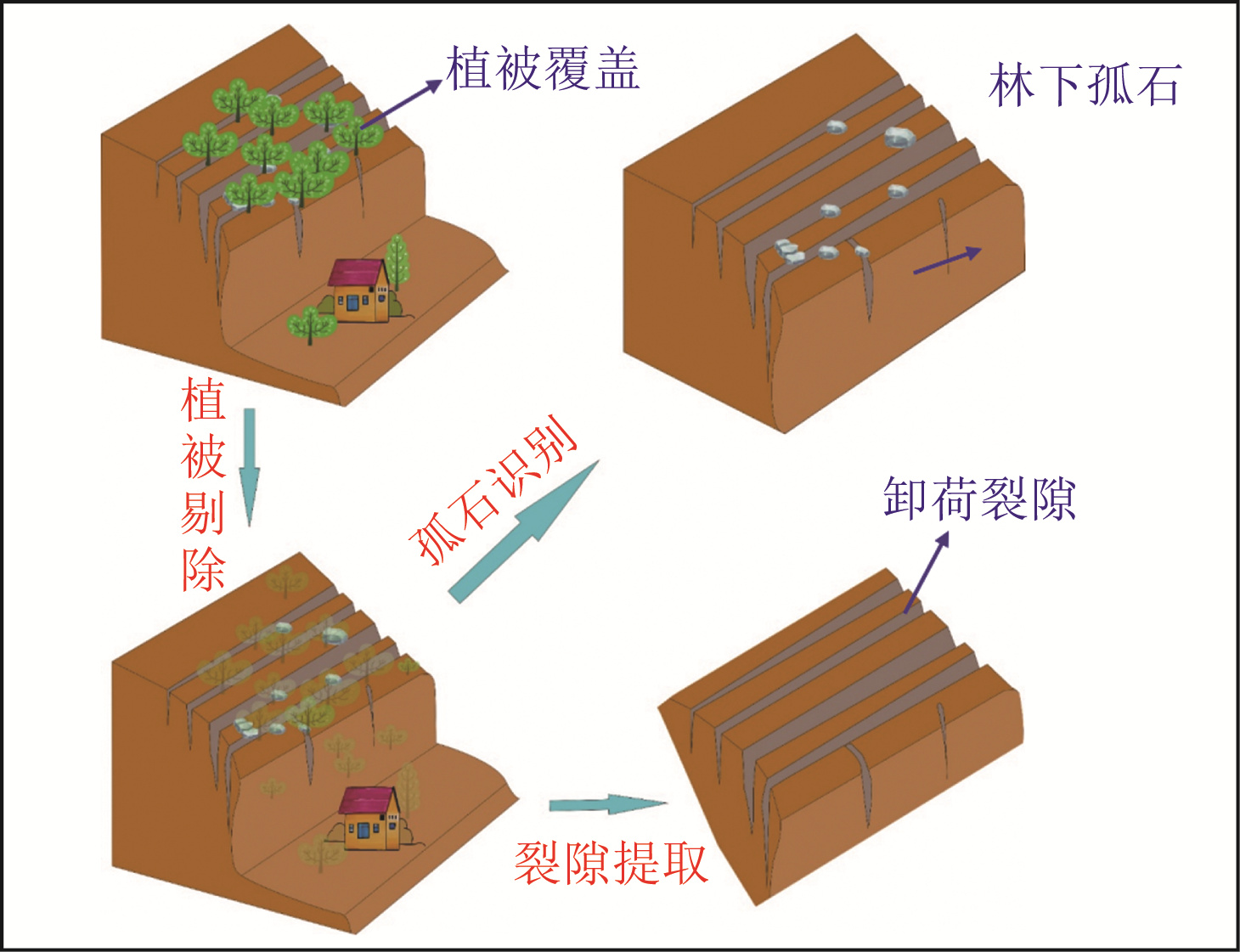
3.1 危岩体裂隙提取与孤石识别
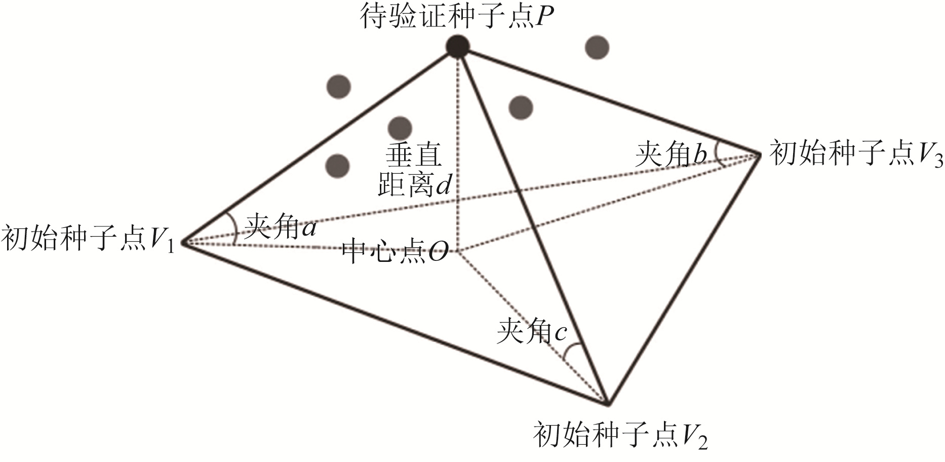
点云滤波分类是机载LiDAR数据处理中重要的一环,本研究中滤波采用目前使用最为广泛的基于不规则三角网(triangulated irregular network,TIN)的逐渐加密算法,算法以图像处理的小波变换为主导,其主要思路如下: 首先,将点云数据进行格网划分,以格网内高程最低点作为种子点生成粗略的TIN模型; 然后,检验格网中所有点与种子点的反复距离与反复角是否小于阈值; 最后,在TIN中加入小于阈值的地面点作为种子点,迭代计算直至不产生新的地面点。其中反复距离、反复角定义如图 2所示,设定三角形三边为初始种子点V1、V2、V3,在三角形外有一待验证种子点P,P到三角形的垂直距离PO的长度为d,d即为反复距离,相应的反复角就是PV1、PV2、PV3与三角形平面的夹角∠a、∠b、∠c。随着滤波的持续进行,反复距离与反复角也相应地不断变化,通常反复角取[6°, 50°), 最终阈值为[2°, 10°)。一般来说,不同地形坡度反复角和阈值不尽相同,因此滤波前需多次测试取最优值。
通过此方法,将具有多次回波的机载LiDAR数据“剔除”植被,获取植被下的真实地表形态,达到危岩体裂隙提取、林下孤石识别的目的(图 3)。一般来说,在同一片区域获取的激光点云密度越大,生成的地形数据越精细,可提取的地形特征越丰富。根据以往工作经验,在植被覆盖一般的情况下,点云密度为60 pt/m2,可识别长宽为1 m× 1 m的林下孤石,可提取[0.2,0.3] m宽的裂隙。
![]() 图 3 危岩体裂隙提取与孤石识别示意图Fig. 3 Schematic diagram of crack extraction and solitary rock identification for dangerous rock masses
图 3 危岩体裂隙提取与孤石识别示意图Fig. 3 Schematic diagram of crack extraction and solitary rock identification for dangerous rock masses3.2 结构面产状信息提取
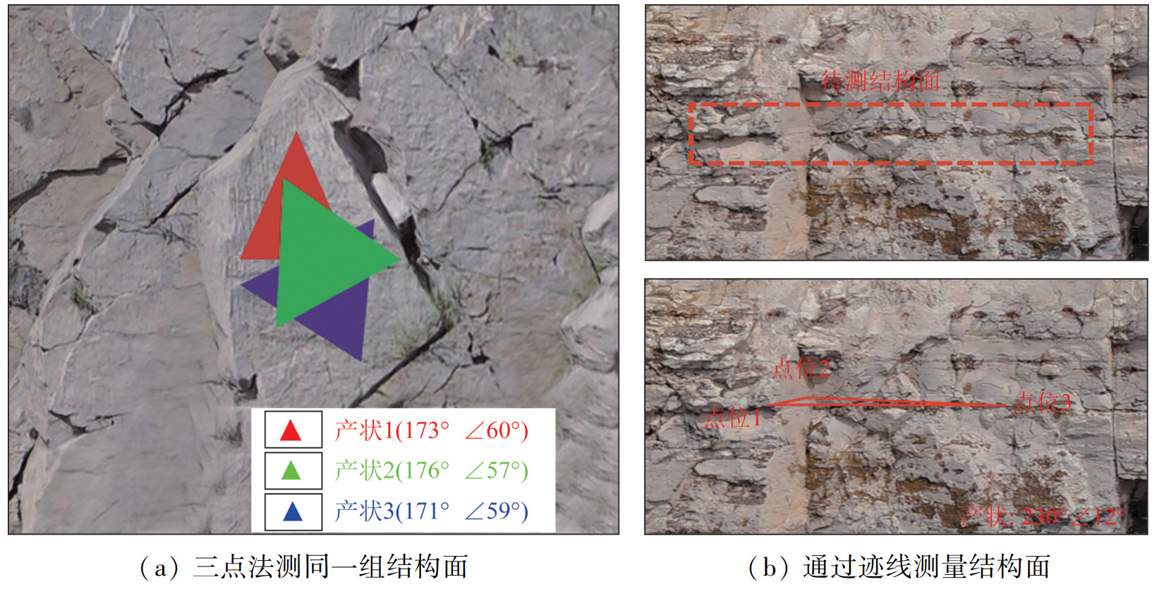
岩溶山区地势险峻,坡体陡立,人难以抵达,无法使用罗盘测量高陡边坡的结构面信息。通过利用实景三维平台,基于三维实景模型的结构面量测,在同一组结构面上选取3个不在同一直线上的坐标点。根据几何原理,3点拟合结构面建立一个平面方程,计算得出结构面的倾向倾角,此方法被称为三点法结构面测量,其计算原理如下。
首先,建立结构面拟合平面方程为
Z=AX+BY+C。 (1) 式中: A、B、C为设定拟合平面方程的参数,且A、B不同时为0,该平面法向量为n=[A, B, 1]。
通过最小二乘法求解A、B、C的值,公式为
[ABC]=[X1Y11X2Y21X3Y31]−1[Z1Z2Z3]∘ (2) 然后,根据结构面产状与平面方程参数的对应关系求得倾角α和倾向β,公式为
α=|arctan(√A2+B2)|。 (3) 设定过程变量β0,为关于A、B的函数,公式为
β0=arctanBA。 (4) 当A < 0时,
{B⩽ (5) 当A>0时,
\beta=\beta_0+\pi。 (6) 式中: A、B含义同式(1),α为倾角, (°),β为倾向, (°)。
值得注意的是,在结构面测量工作中,往往需要检验结构面与三点拟合平面的重合度(图 4(a)),以减小人工测量所带来的误差。采用三点法测量同一平整结构面,各测量结果误差较小,可满足地质灾害调查的精度要求。但地质调查中往往遇到岩体结构面倾角较小,结构面仅以迹线的形态出露。对于此类结构面,可以利用其中在空间的转折部位,选取空间上不在同一直线上的3个点,通过迹线来完成结构面的量测工作(图 4(b))。
3.3 结构面特征参数信息提取
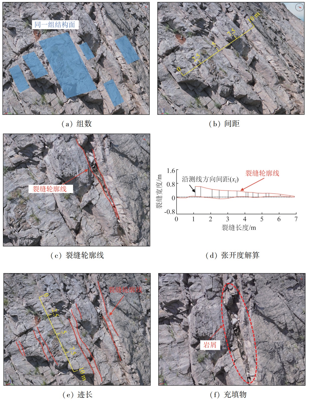
为研究危岩体稳定性,其结构面组数和间距、迹长、张开度和充填物等信息也是重要参数,通过三维实景模型,可代替卷尺、皮尺快速完成量测工作,如图 5所示。
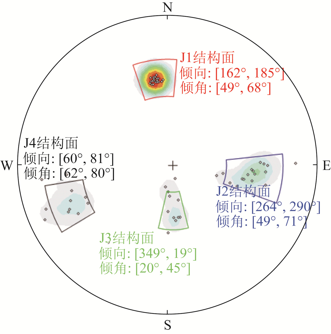
(1) 结构面组数和间距。结构面分组是结构面调查的重要内容,岩体结构面优势组划分是把具有相似产状方位的结构面划分到同一组,然后对岩体的结构面系进行分析。在研究结构面产状时,往往采用将测量得到的结构面的产状绘制玫瑰花图、极点图或密度投影图,然后再比较投影图产状极点分布的相似性和疏密程度,以达到将结构面产状进行优势组划分的目的。本研究拟采用结构面极点图进行结构面分组,如图 6所示。岩体结构面组数越多,结构面间距越小,则岩体切割越破碎,其是判断岩体稳定性的重要参数。在三维实景模型上,测量岩体结构面,统计测线与同一组结构面相交的数量与长度,采用式(7)计算结构面的平均间距,公式为
\bar{x}=\sum\limits_{i=1}^n x_i / n。 (7) 式中: x表示结构面的平均间距,m; xi表示沿长度为x的测线测量i个结构面的不连续间距,m; n表示结构面组数。
(2) 结构面迹长。大量实践表明,迹线越长,对岩体整体稳定性影响就越大。用直线连接结构面上最长的端点作为迹线,其在露头处的出露长度用迹长表示,通过三维实景模型,可以方便快捷地测量其迹长,同时可完成迹长的矢量化工作,以便加入其他软件进行数理统计分析。
(3) 结构面张开度和充填物。结构面的张开度与充填物是分析岩体稳定性的重要参数。通过一定间距垂直于裂隙两端端点连线布设若干测线,求得的测线与裂隙边缘两迹线交点之间的平均距离即为结构面张开度,其通过三维实景模型可直接量取。
4 成果及讨论
4.1 结构面解译成果及讨论
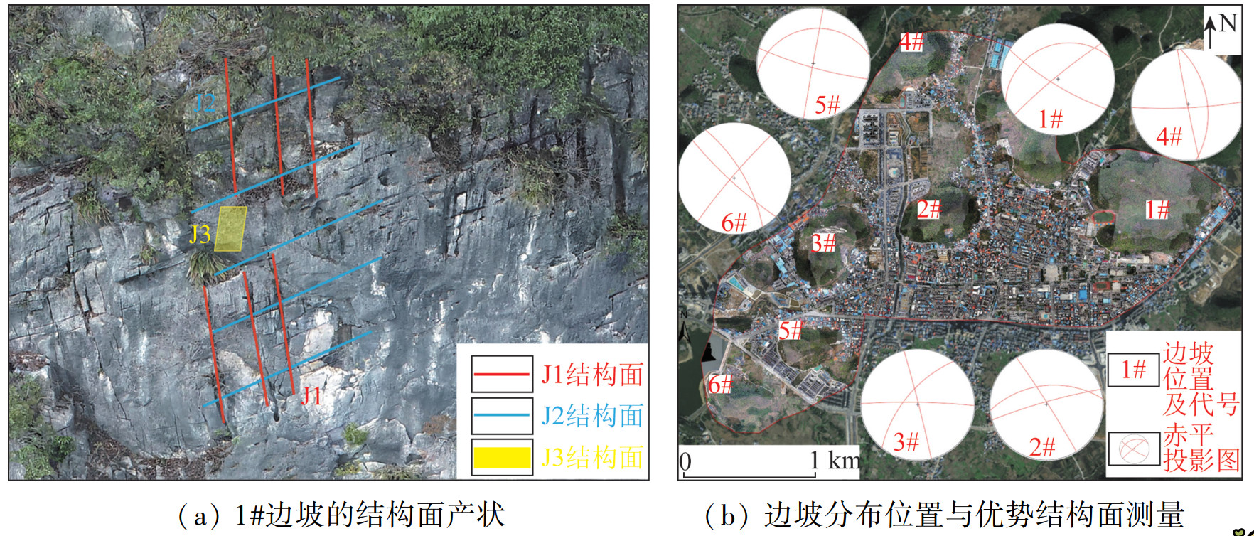
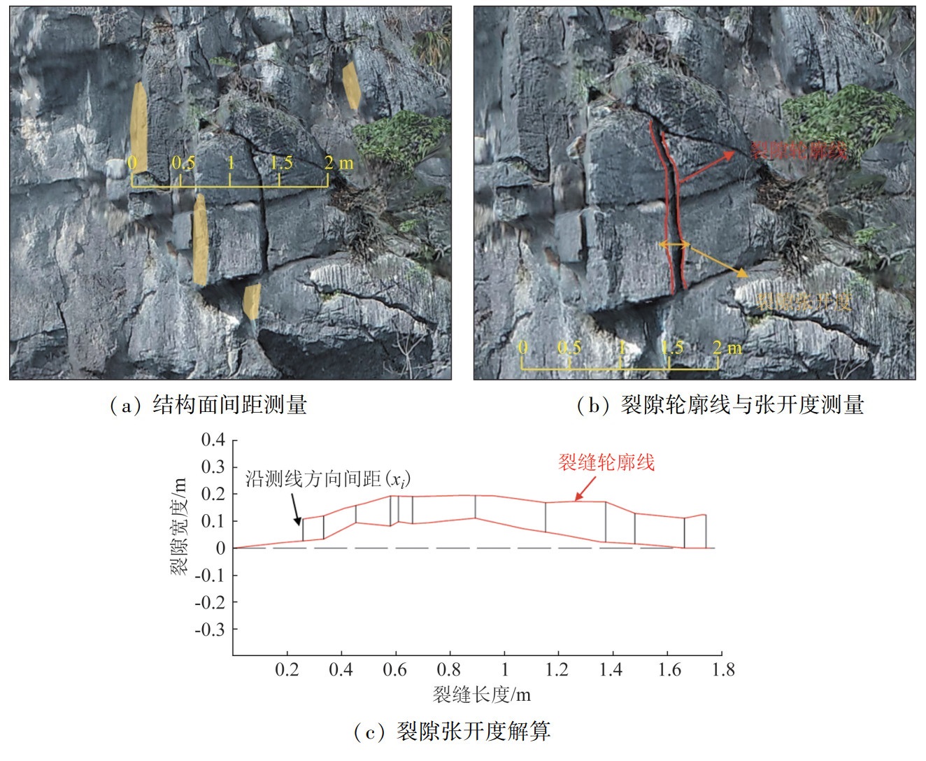
基于已有地质资料和现场获取的多源遥感数据,通过采用投影变换、格式转换、属性标准化、数据空间化等技术方法和手段,在Earthsurvey软件平台上完成多源数据融合,开展综合遥感解译。研究结果表明,区内基岩发育多组构造结构面,随着人类工程活动的不断加强、季风气候不断的风化侵蚀,使得原切割完整的岩体发育更多的次生裂隙和软化破坏,因此基岩岩体完整性和稳定性大大降低,同时在重力卸荷裂隙的影响下,造成了边坡危岩体隐患的频发。在三维实景模型数据中,通过对出露结构面信息采用多点拟合平面方法,实现结构面提取,并由平面方程参数计算获得结构面产状信息。如图 7(a)所示,区内大多数危岩体隐患点发育2~3组控制结构面,这些结构面通常决定着岩体的稳定性和失稳方向。结合地形坡度、岩体完整性、植被发育情况及威胁对象,在研究区内选取了6处边坡辨识优势结构面,识别结果如图 7(b)所示。各区域参数如下: 1# 边坡,J1结构面为32°∠78°,J2结构面为157°∠27°,J3结构面为140°∠84°; 2#边坡,J1结构面为164°∠84°,J2结构面为238°∠87°,J3结构面为174°∠52°; 3#边坡,J1结构面为256°∠88°,J2结构面为181°∠85°,J3结构面为129°∠64°; 4#边坡,J1结构面为357°∠83°,J2结构面为79°∠88°,J3结构面为262°∠53°; 5#边坡,J1结构面为16°∠82°,J2结构面为100°∠89°,J3结构面为171°∠26°; 6#边坡,J1结构面为43°∠82°,J2结构面为240°∠71°,J3结构面为130°∠85°。研究对重点区域危岩体展开结构面特征参数信息测量,如1#边坡J1结构面的岩体受强烈应力切割,局部结构面间距可达0.5 m,裂隙张开度为[0.1, 0.15) m(图 8),加之植被的根劈作用,岩体较为破碎。
![]() 图 8 1#边坡J1结构面特征参数提取Fig. 8 Feature parameter extraction of J1 structural plane on slope 1#
图 8 1#边坡J1结构面特征参数提取Fig. 8 Feature parameter extraction of J1 structural plane on slope 1#4.2 危岩体遥感解译成果及讨论
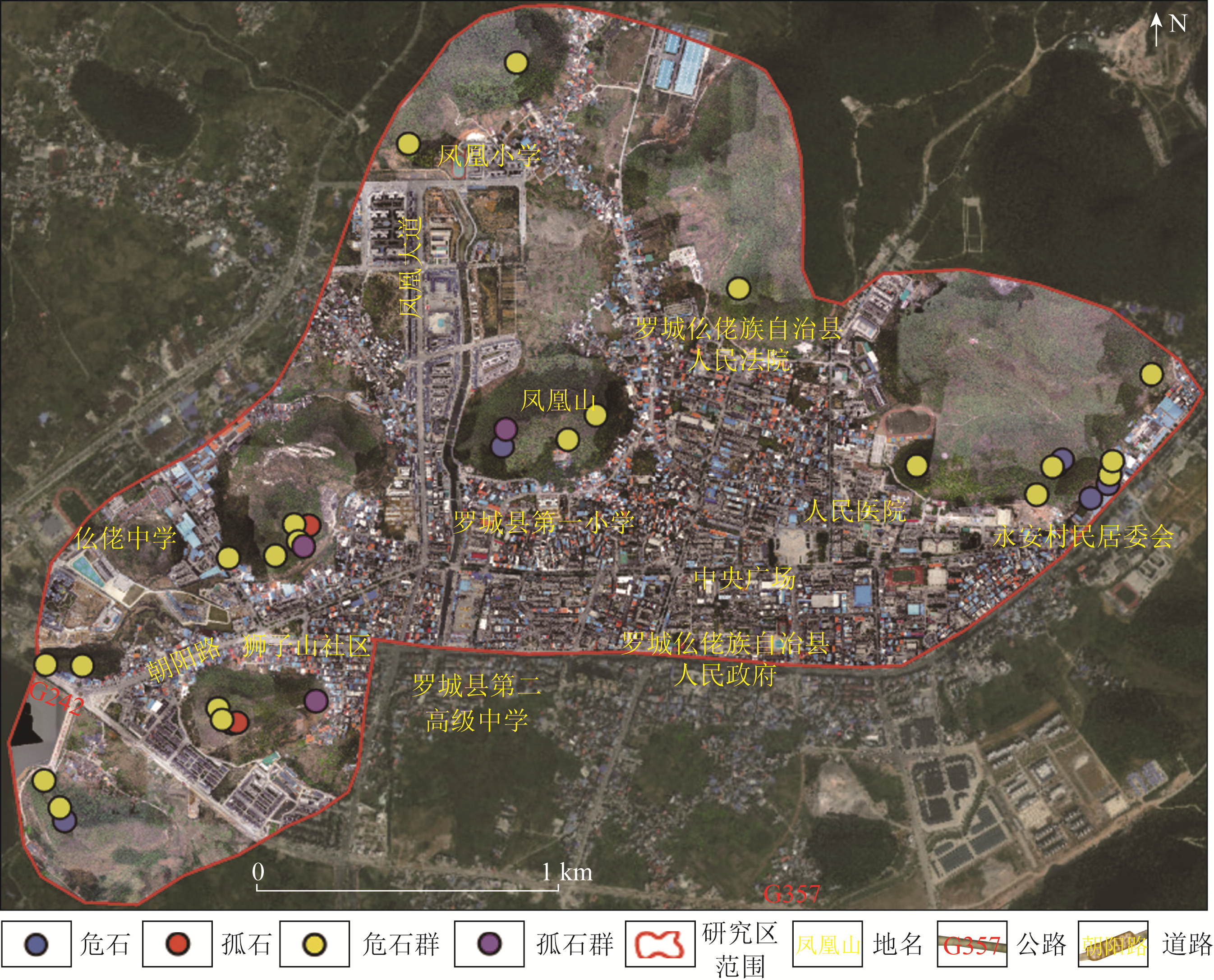
基于多源数据遥感解译结果,并结合野外复核验证,本研究共识别出34处危岩体,其中包括6处危石,21处危石群,4处孤石,以及3处孤石群(图 9)。
![]() 图 9 研究区危岩体解译分布Fig. 9 Distribution of interpreted dangarous rock masses in the study area
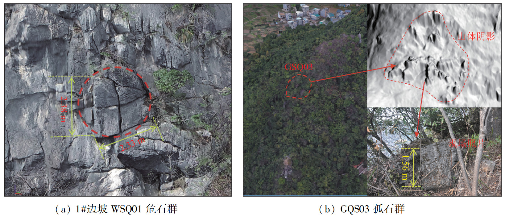
图 9 研究区危岩体解译分布Fig. 9 Distribution of interpreted dangarous rock masses in the study area研究区危石及危石群多位于边坡上部及中部,地势较为陡峭。经调查研究发现,危石多分布于边坡陡崖或陡缓交界处,地形陡立,表面粗糙,部分基岩裸露,有时可见下部堆积。危石裂隙处和已经卸荷掉块处在边坡上往往色调较浅,与周围岩体色差明显,且无植被生长,下部可能还有呈较浅色调的崩塌落石滚落痕迹。利用机载LiDAR生成的DEM数据,在1#坡危石群处出现严重的拉花现象,通过贴近摄影测量获得的三维实景模型则展现出了较好的效果(图 10(a))。调查显示,区内的危石及危石群普遍受到多组结构面的切割,节理裂隙发育,地形坡度较陡,临空条件较好,危石尚未与母岩完全脱离。在植被“根劈”作用下,裂隙可能进一步发展扩大。危石群内包含多个危岩块体,一般为不规则块状,其风化程度一般为中等。针对此类坡度较陡的危岩体,常规的机载LiDAR平行航线往往会出现陡立面处点云密度不高,造成DEM山体阴影影像出现“拉花”现象,航测时设计“井”字航线采集数据,往往能改善数据质量,提高危岩体的识别准确性。
![]() 图 10 危岩体识别及三维实景模型影像Fig. 10 Identification of dangerous rock masses and images of the three-dimensional real-scene model
图 10 危岩体识别及三维实景模型影像Fig. 10 Identification of dangerous rock masses and images of the three-dimensional real-scene model研究区内孤石多位于斜坡中部及坡脚区域,孤石表现为已脱离母岩,停留于坡表堆积层。已经发生崩塌的区域,落石在坡表集中堆积,形成了孤石群。由于区内坡表植被茂盛,仅通过三维实景模型难以辨识林下的孤石。而利用激光LiDAR技术的“剔除”植被功能,可以在生成的DEM上清晰地识别出林下孤石。在LiDAR影像上发现: 危岩临空面较好,影像纹理斑驳,与周围岩体纹理存在明显差异,表面坎坷不平,呈现毛刺状的特征; 孤石凸起特征明显,表面较为粗糙,边界特征清晰(图 10(b))。后续的现场实地复核进一步证实了机载LiDAR技术在林下孤石识别方面的可行性。
5 结论
(1) 运用基于不规则三角网的逐渐加密算法对机载LiDAR点云进行处理,有效“剔除”植被,反映真实地形特征,达到了提取危岩体裂隙和林下孤石的目的。
(2) 通过三维实景模型,对研究区危岩体结构面的产状几何信息,以及结构面特征参数如组数和间距、迹长、张开度与充填物进行分析,实现了危岩体几何特征信息的提取。
(3) 将研究技术方法成功应用于罗城县城区域,开展了危岩体的精细化调查工作,区内共识别出34处危岩体,其中,危石6处,危石群21处,孤石4处及孤石群3处,证明了技术方法的可行性,可为类似边坡危岩体调查提供准确、快速且有效的方法。
(4) 通过结合机载LiDAR技术和摄影测量技术的优势,做到优势互补,使危岩体调查工作更加全面细致,提高了调查精度和效率。
-
![]()
图 1 研究区和典型危岩体发育区位置
Figure 1. Location of the study area and typical development areas of dangerous rock masses
![]()
图 3 危岩体裂隙提取与孤石识别示意图
Figure 3. Schematic diagram of crack extraction and solitary rock identification for dangerous rock masses
![]()
图 8 1#边坡J1结构面特征参数提取
Figure 8. Feature parameter extraction of J1 structural plane on slope 1#
![]()
图 9 研究区危岩体解译分布
Figure 9. Distribution of interpreted dangarous rock masses in the study area
![]()
图 10 危岩体识别及三维实景模型影像
Figure 10. Identification of dangerous rock masses and images of the three-dimensional real-scene model
表 1 低空遥感数据获取情况
Table 1 Data acquisition situation of low-altitude remote sensing
数据类型 工作设备 数据采集主要参数 成果类型 机载LiDAR D20+DVLiDAR20 点云密度60 pt/m2 DEM、数字表面模型(digital surface model, DSM) 倾斜摄影测量 D200+ OP310 分辨率5 cm 倾斜三维实景模型、数字正射影像(digital orthophoto map, DOM) 贴近摄影测量 DJI Phantom4RTK 分辨率5 mm 贴近三维实景模型  下载: 导出CSV
-
[1] 郭静芸, 李守定, 李滨, 等. 岩溶山区崩滑灾害变形破坏地质模式分类[J]. 中国岩溶, 2020, 39(4): 478-491. Guo J Y, Li S D, Li B, et al. Geological models classification of deformation and failures for collapses and landslides in karst mountainous areas[J]. Carsologica Sinica, 2020, 39(4): 478-491.
[2] 董秀军, 黄润秋. 三维激光扫描技术在高陡边坡地质调查中的应用[J]. 岩石力学与工程学报, 2006, 25(S2): 3629-3635. Dong X J, Huang R Q. Application of 3D laser scanning technology to geologic survey of high and steep slope[J]. Chinese Journal of Rock Mechanics and Engineering, 2006, 25(S2): 3629-3635.
[3] 武鹏, 黄华平, 缪志修. 地面三维激光扫描技术在川藏铁路危岩落石勘察中的应用[J]. 测绘与空间地理信息, 2017, 40(11): 218-220. Wu P, Huang H P, Miao Z X. Application of 3D laser scanning technology to survey holding Rockfall of Sichuan-Tibet railway[J]. Geomatics & Spatial Information Technology, 2017, 40(11): 218-220.
[4] 齐云龙, 张立, 刘玉洁, 等. 利用三维激光扫描仪的崩塌危岩体识别技术[J]. 公路交通科技: 应用技术版, 2018, 145(10): 171-172. Qi Y L, Zhang L, Liu Y J, et al. Identification technology of landslide hazardous rock mass using 3D laser scanner[J]. Journal of Highway and Transportation Research and Development: Application Technology Edition, 2018, 14(10): 171-172.
[5] 崔溦, 谢恩发, 张贵科, 等. 利用无人机技术的高陡边坡孤立危岩体识别[J]. 武汉大学学报: 信息科学版, 2021, 46(6): 836-843. Cui W, Xie E F, Zhang G K, et al. Identification of isolated dangerous rock mass in high and steep slope using unmanned aerial vehicle[J]. Geomatics and Information Science of Wuhan University, 2021, 46(6): 836-843.
[6] 党杰, 董吉, 何松标, 等. 机载LiDAR与地面三维激光扫描在贵州水城独家寨崩塌地质灾害风险调查中的应用[J]. 中国地质灾害与防治学报, 2022, 33(4): 106-113. Dang J, Dong J, He S B, et al. Application of airborne LiDAR and ground 3D laser scanning in geological hazard risk investigation of Dujiazhai collapse in Shuicheng, Guizhou[J]. The Chinese Journal of Geological Hazard and Control, 2022, 33(4): 106-113.
[7] 刘桂卫, 李国和, 陈则连, 等. 多源遥感技术在艰险山区铁路地质勘察中应用[J]. 铁道工程学报, 2019, 36(8): 4-8. Liu G W, Li G H, Chen Z L, et al. Application of remote sensing technology for geological investigation in mountain railways[J]. Journal of Railway Engineering Society, 2019, 36(8): 4-8.
[8] 王文涛. 倾斜航空摄影技术在茂密植被山区地质灾害调查中的应用[J]. 中国地质调查, 2024, 11(2): 116-122. doi: 10.19388/j.zgdzdc.2024.02.14 Wang W T. Application of oblique aerial photography technology in the geological hazard investigation in dense vegetation mountainous areas[J]. Geological Survey of China, 2024, 11(2): 116-122. doi: 10.19388/j.zgdzdc.2024.02.14
[9] 郑斯见. 无人机航空摄影测量在矿区地形测绘中的应用研究[J]. 世界有色金属, 2023(16): 232-234. Zheng S J. Research on the application of drone aerial photogrammetry in mine topographic mapping[J]. World Nonferrous Metals, 2023(16): 232-234.
[10] 夏雄彬, 谯立家, 许万忠. 基于机载LiDAR及无人机影像的高位危岩体调查和成因分析[J]. 长江科学院院报, 2023, 40(9): 188-194. Xia X B, Qiao L J, Xu W Z. Investigation and cause analysis of dangerous rock masses on high and steep slope based on airborne LiDAR and UAV imagery[J]. Journal of Changjiang River Scientific Research Institute, 2023, 40(9): 188-194.
[11] 罗崴, 黄之巍. 无人机摄影测量技术在危岩勘查中的应用[J]. 广西水利水电, 2021(5): 30-35. Luo W, Huang Z W. Application of UAV photogrammetry technology in dangerous rock investigation[J]. Guangxi Water Resources & Hydropower Engineering, 2021(5): 30-35.
[12] 黄海宁, 黄健, 周春宏, 等. 无人机影像在高陡边坡危岩体调查中的应用[J]. 水文地质工程地质, 2019, 46(6): 149-155. Huang H N, Huang J, Zhou C H, et al. Application of UAV images to rockfall investigation at the high and steep slope[J]. Hydrogeology & Engineering Geology, 2019, 46(6): 149-155.
[13] 梁京涛, 铁永波, 赵聪, 等. 基于贴近摄影测量技术的高位崩塌早期识别技术方法研究[J]. 中国地质调查, 2020, 7(5): 107-113. doi: 10.19388/j.zgdzdc.2020.05.12 Liang J T, Tie Y B, Zhao C, et al. Technology and method research on the early detection of high-level collapse based on the nap-of-the-object photography[J]. Geological Survey of China, 2020, 7(5): 107-113. doi: 10.19388/j.zgdzdc.2020.05.12
[14] 姚富潭, 吴明堂, 董秀军, 等. 基于贴近摄影测量技术的高陡危岩体结构面调查方法[J]. 成都理工大学学报: 自然科学版, 2023, 50(2): 218-228. Yao F T, Wu M T, Dong X J, et al. Investigation method of discontinuity in high and steep dangerous rock mass based on nap of the object photogrammetry[J]. Journal of Chengdu University of Technology (Science & Technology Edition), 2023, 50(2): 218-228.
[15] 程雨柯, 李亚虎, 夏金梧, 等. 无人机技术在超高陡边坡危岩体半自动识别中的应用[J]. 中国地质灾害与防治学报, 2024, 35(1): 143-154. Cheng Y K, Li Y H, Xia J W, et al. Application UAV technology semi-automatic identification dangerous rock masses on ultra-high steep slopes[J]. The Chinese Journal of Geological Hazard and Control, 2024, 35(1): 143-154.
[16] 董秀军, 许强, 佘金星, 等. 九寨沟核心景区多源遥感数据地质灾害解译初探[J]. 武汉大学学报: 信息科学版, 2020, 45(3): 432-441. Dong X J, Xu Q, She J X, et al. Preliminary study on interpretation of geological hazards in Jiuzhaigou based on multi-source remote sensing data[J]. Geomatics and Information Science of Wuhan University, 2020, 45(3): 432-441.
[17] 蔡立标. 地质灾害发育特征及形成机制分析[J]. 世界有色金属, 2018(16): 264-265. Cai L B. Development characteristics and formation mechanism of geological hazards[J]. World Nonferrous Metals, 2018(16): 264-265.
[18] 刘祥. 广西罗城仫佬族自治县地质特征及矿山地质灾害预测[J]. 资源信息与工程, 2020, 35(4): 14-16. Liu X. Geological features and mine geological hazard forecast of Luocheng Gelao Autonomous County, Guangxi[J]. Resource Information and Engineering, 2020, 35(4): 14-16.
计量
- 文章访问数: 16
- HTML全文浏览量: 2
- PDF下载量: 5
